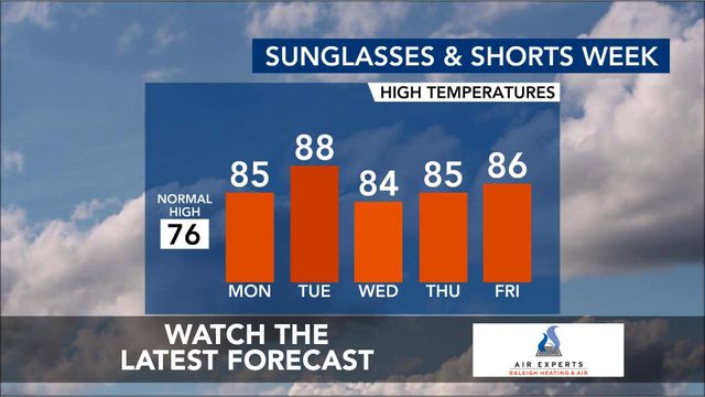
Soak up the sun! Sunshine and temps in the 80s much of the week
Sunday morning was cool, with temps in the 50s ahead of a sunny, warm day.
Throughout the afternoon, temps will warm up into the low 80s, making it a mild day ahead of a week when temps could reach record-breaking highs.
We could see temperatures as high as 90 degrees in the upcoming week.
- Sunday: Partly cloudy. High of 82.
- Monday: A mainly sunny sky. Very warm. High 86.
- Tuesday: Partly cloudy. Very warm. High 87.

Record heat possible next week
The end of April and beginning of May will be hot, with record heat possible on Tuesday. Highs could reach 90 degrees for the first time this year and possibly break a record.

Temperatures will stay in the 80s for most of next week. It'll be a great week to get outside! Our only potential rain chances would be Tuesday and Tuesday night of next week with some isolated showers possible.

With all this warm weather, the flowers and trees are blooming – meaning pollen counts are high. If you're sneezing, spring allergies could be to blame.

7-day forecast for central NC
- Sunday: Cloudy and warm with highs in the low 80s.
- Monday: Clear skies and warmer. High of 86.
- Tuesday: Sunshine and some clouds. High 88.
- Wednesday: A few passing clouds, otherwise generally sunny. High 87.
- Thursday: Sunshine and clouds mixed. High 79.
- Friday: Partly cloudy skies. High 86.

Prepare for a busy 2024 Atlantic hurricane season
The 2024 Atlantic hurricane season will see 15 to 20 named storms in the Atlantic basin, according to researchers at North Carolina State University.
The number of named storms is significantly higher than the long-term average, and moderately higher than recent 30-year averages, according to Lian Xie, professor of marine, earth and atmospheric sciences at NC State.
In 2024, NC State researchers predict:
- 15 to named storms
- 10 to 12 may grow strong enough to become hurricanes (the historical average is six)
- Three to four becoming major hurricanes
Meanwhile, forecasters at Colorado State University are calling for 24 named storms in the 2024 Atlantic hurricane season, which runs from June 1 through Nov. 30. That is higher than the average year, when 14 storms earn a name.
CSU forecasters say 11 storms will reach hurricane strength, up from the average of seven, and five of those hurricanes could be "major," that is Category 3, 4 or 5, with winds over 111 mph.


